 Google unveiled on Saturday in Rio de Janeiro a cultural map of the Amazonian Surui tribe, a digital application that will help this population of the Amazon basin to share with the whole world their voluminous knowledge of the forests and thus combat deforestation, informs lemonde.fr. The map, result of a five-year partnership between Almir, Surui tribe chief, and technology giant Google, was presented in a world premiere at a forum of companies, organized during the series of events preceding World Conference on Sustainable Development “Rio +20”.
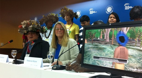
On the animated image representing our planet created by Google Earth you can see a small point, which is an area of the Brazil territory: it’s the place where 1,300-member Surui tribe live, in a 600,000 acres area in the Rondonia State, north-west of the country. The application shows photos and videos in 3D of the forest where the indigenous population live, accompanied by descriptions of their customs and traditions. These images can be found on Google Earth, and also on Paiter.org site.
Wearing a “hat” of multicolored feathers, tribal chief, Almir, welcomed the project which “showed the whole world, with Google’s help, the value of our culture”. Almir, who proposed the idea of creating the map to Google during a journey in the United States five years ago, said in a press conference that he is particularly proud of Surui tribe contribution to this project, especially the narrative parts. Almir said that tribe members will use this map and smartphones to monitor illegal deforestation around their territory. The Amazonian tribe leader said that his goal is to raise awareness among people about the need for sustainable use of forests. “We know the forest, Google knows the technology, and we signed a partnership for forest wealth,” he added.
Representatives of the U.S. technology group said in turn that the same technology will be used to help other indigenous tribes in the world, including Canada and New Zealand. In 2011, Google has already mapped a major section of the Amazon Rio Negro basin, turning into the heart of forest its Street View program, which allows Internet users to explore cities with images that can rotate 360 degrees.
Reply